22 Jan Australia’s New Year Under Pressure
Responding Faster in Times of Disaster – Helping Impacted Businesses

Australia has entered the New Year facing a stark reminder of the growing intensity and frequency of extreme natural events. Across multiple states, communities are grappling with fires, floods and severe storms that have caused widespread disruption, property loss, and displacement.
In Victoria, fires that ignited in early January have destroyed homes and infrastructure across Corangamite, Mount Alexander, Horsham and other declared disaster zones in the Upper Murray and Strathbogie Ranges. Along the state’s iconic Great Ocean Road, a highly localised but severe storm system delivered intense rainfall that triggered rapid flash flooding. Holiday towns including Lorne and Wye River were hit hard as waterways were overwhelmed and floodwaters swept through streets and businesses.
New South Wales has also been under significant pressure. Sydney recorded its wettest January day in 40 years, with torrential rain overwhelming drainage systems, triggering landslides and prompting thousands of callouts to the State Emergency Service. Further north, Central Queensland has experienced extraordinary rainfall, with the town of Clermont recording more than 200 millimetres in just 24 hours, its heaviest rainfall since 1916, breaching riverbanks and inundating surrounding areas.
The Urgency of Targeted Disaster Recovery
When areas are declared natural disaster zones, state and federal governments may activate disaster recovery payments to support affected households and businesses. While these payments are critical, they also present an immediate challenge: how to quickly and accurately identify who has been impacted, and where support is needed most.
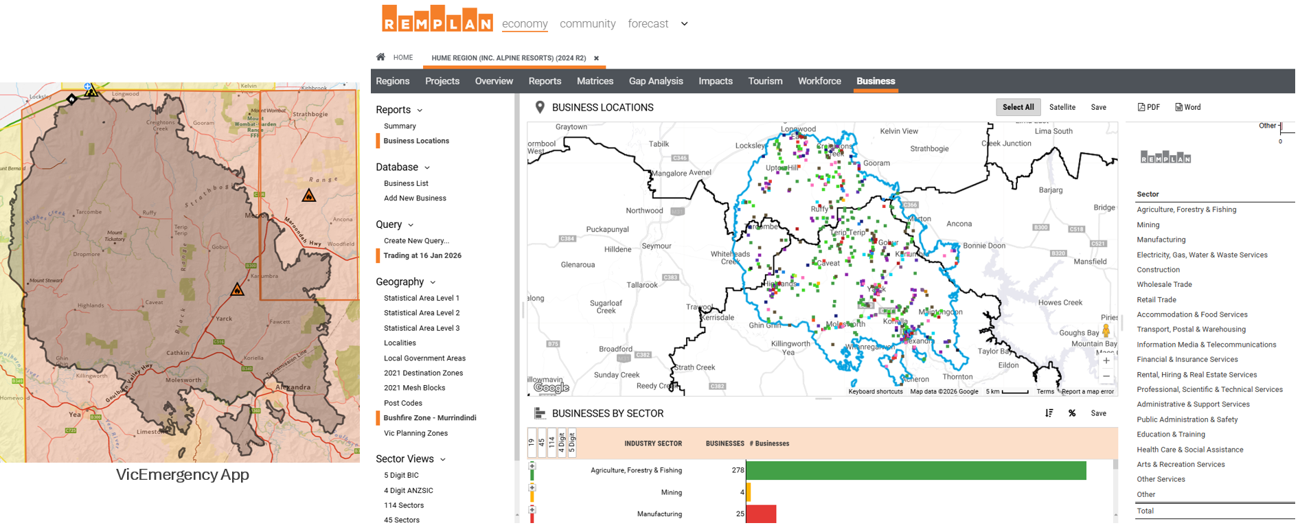
For businesses, this task relies heavily on place-specific data. Australian government agencies have access to comprehensive business identity information held in the Australian Business Register (ABR). Managed by the Australian Taxation Office (ATO), the ABR contains public details such as business names and ABNs, alongside non-public information, including contact details and trading addresses, that government agencies can use for policy development, fraud prevention, and emergency support.
Importantly, ABR data is geo-coded by the ATO, enabling business locations to be visualised on digital maps and analysed through platforms such as REMPLAN Economy. This spatial capability becomes critical during emergency response, when time and accuracy matter most.
Mapping Impacts to Support Recovery
In disaster-affected regions, REMPLAN has been working closely with local councils to support rapid, evidence-based decision-making. By applying official impact zone mapping layers from government sources, including tools such as the VicEmergency app, to the Business tab within REMPLAN Economy, councils can quickly see which businesses fall within declared impact zones. This helps bridge the gap between emergency declarations and practical recovery action.
This approach enables faster identification of affected businesses, supports more targeted communication, and assists governments and councils to direct limited recovery resources where they are most urgently needed.
As communities across Australia continue to respond to these unfolding events, the ability to combine business data with spatial intelligence is proving essential.
Turning Impact Zones into Action
The first step in delivering timely business support during an emergency is clearly defining the impact zone. Councils and agencies can advise REMPLAN of the required area by supplying a digital map, such as an ESRI shapefile, or by directing us to an authoritative source like the VicEmergency map. From there, our team generates the impact zone map and integrates it directly into REMPLAN Economy.
For Australian Government agencies with access to current ABR data, this process enables rapid results. Once an impact zone is confirmed, a list of businesses located within the affected area can typically be produced within 12 to 24 hours. This speed is critical in disaster situations, where early identification supports faster outreach and better-targeted assistance and allocations of recovery payments for businesses under immediate pressure.
By transforming emergency mapping into actionable business intelligence, REMPLAN helps governments move from declaration to delivery when communities need it most.
Next Steps: Talk to Us
If your community or region has been impacted by a declared disaster, the next step is to contact REMPLAN to discuss your requirements. Our team can work with you to define impact zones, apply the appropriate data layers, and rapidly identify affected businesses to support timely recovery and response efforts.

No Comments